A Diverse Selection of Geomatic and Engineering Services
3D – LASER SCANNING
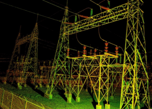
3D Laser Scanning is a non-contact, non-destructive technology that digitally captures the shape of physical objects using a line of laser light. 3D laser scanners create “point clouds” of data from the surface of an object and is a method to capture a physical object’s exact size and shape into the computer world as a digital 3-dimensional representation.
These comprehensive digital records can be re-used and updated without limit to extract new information and reveal key elements about a project site or answer new questions as they arise. This measurable data forms the basis for design, enhancing planning and quality control while enabling better documentation and project outcomes.
Laser Scanning provides many advantages over conventional mapping of sites:
▶ High-detailed, high-precision imagery
▶ Point in time record and digital archive
▶ Less return trips to acquire additional information
Services include:
▶ Scan only, cleaned point cloud
▶ Scan to CAD
▶ Scan to BIM
COMMERICAL BUILDING STAKING
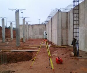
Commercial Building Staking is performed to ensure the accurate placement of horizontal and vertical design features within a given project. Whether a building project is single storey with a vast footprint, or multiple storey with a small footprint, transfer of design lines, horizontally and vertically with minimum error is of the utmost importance.
The complexity of the project dictates the software and hardware components to be untitled to ensure design tolerances are met.
A strict and rigorous protocol is followed both in the office and in the field to ensure that any errors that may occur are found and addressed prior to the layout element being constructed. Such protocols include:
▶ Review of IFC Drawings for misclosure, omissions and errors, with reporting on such.
▶ Submission of layout sheets for contractor review and acceptance
▶ Redundant field measurements on staking, and a field QC/QA before leaving site.
▶ Remote data submission to office for QC/QA check on field layout, with verification of staking before field crew leaves site.
▶ QC/QA reporting of construction staking.
Services typically combined with Commercial Building Staking include:
▶ Reposting of property corners.
▶ Verification of location and elevation of connecting infrastructure
▶ Benchmarks and control for contractor.
▶ Confirmation of buildings location on architectural and engineering drawings
▶ Lot staking for excavation.
▶ Foundation staking for footing placement.
▶ Grid line and batter board alignment and positioning.
▶ Structural bearing bolt layout
▶ Quality Control and Quality Assurance reporting
RESIDENTIAL SURFACE DRAINAGE PLAN
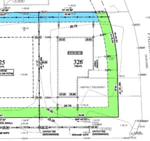
Surface Drainage Plans, also known as a Lot Grading Plans, help preserve the natural environment, minimize sewer system problems, and reduce the impacts of any increased stormwater runoff, flow quantity, erosion and pollutions resulting from new development.
The purpose of lot grading is to provide drainage away from buildings for the benefit of property owners while ensuring water does not run onto neighbouring properties.
Surface Drainage Plans specify design elevations, surface gradients, lot types, swale locations, and other drainage information required for lot grading.
Municipalities typically require the surface drainage plan as part of the document submission prior to issuing a building permit. A final certified grading plan is required prior to issuing an occupancy permit.
Services typically combined with Residential Surface Drainage Plan include:▶ Reposting of property corners.
▶ Topographic survey for surface drainage plan design.
▶ Benchmarks and control for client’s contractors.
▶ Confirmation of site elevations and services with record drawings.
▶ Surface Drainage Plan (Site plan) with building(s) situation, and proposed grades for property.
▶ Lot staking for excavation.
▶ Foundation staking for footing placement.
▶ Foundation staking with nails in footing.
▶ Footing Certificate for municipal compliance.
▶ Rough Grading Plan for municipal compliance
▶ Final Grading Plan and certification of compliance to the municipality for occupancy permit.
LAND DEVELOPMENT
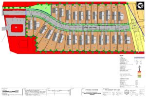
Land development is a dynamic process that commences with raw land and ends with the completion of the finished product. The development may be residential, commercial, intuitional industrial or any such combination.
The development of a raw parcel of land is a comprehensive process that involves input and approvals from many stakeholders, which is someone dictated by the size of the development under review.
A typical land development proposal would include:
▶ A review/creation of strategic plans, policies and guidelines
▶ A review the structure of the area and its neighbourhoods
▶ Re-zoning, Land Consolidation and Subdivision
▶ Development and Servicing Agreements
▶ Development Permitting
▶ Building Permits
▶ Licenses of Occupation, etc
▶ Finished Development
Services typically combined with Land Development include:
▶ Retracement Surveys
▶ Topographic Surveys
▶ Pre-Engineering Design
▶ Comprehensive Site Planning
▶ Regulatory review and Public Presentations
▶ Storm water Management Plans
▶ Site Design and Engineering
▶ Project Management and Construction Administration
▶ Control Surveys
▶ Road and Services Construction Layout
▶ Residential Building Layout
▶ Commercial Building Layout
▶ As-Built Record Drawings
